Archive for Dixie National Forest

Day 3 – Red Canyon, Bryce Canyon

Posted in Photography, Travel with tags , , , , , on 12 October 2013 by Richard Hornbaker

[This post is part of The Accidental Photo Adventure]

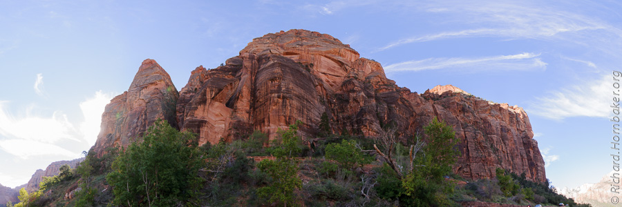
Leaving Zion National Park

We slept in a little, then hit the visitor’s center on our way out. Our route was back out the North-East entrance of the park, through Kanab, Utah. Clouds had rolled in, so we stopped strategically to take a handful of retakes, killing about an hour along the way. What a difference it made to have clouds in the sky!

DDD_1907-Pano

This is looking in the opposite direction, toward the tunnel entrance:
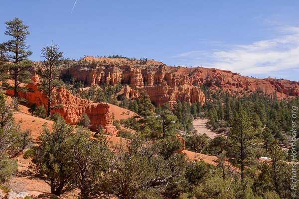
DDD_1934-Pano

Red Canyon

Along the route from Zion to Bryce Canyon is Red Canyon, part of Dixie National Forest. It’s a small place, but colorful. Red Canyon’s soil is a dark red like Sedona, AZ, which makes for a very picturesque contrast with the green foliage and blue skies – especially if it’s lightly cloudy.

DDD_1949

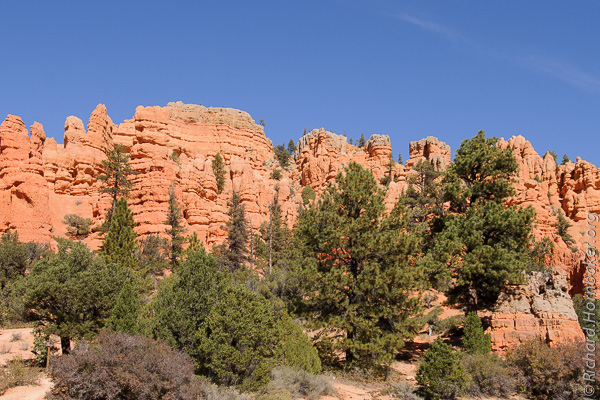
Just inside the entrance to Red Canyon is a feature with short trails to photo vantage points and great panoramic vistas.

DDD_1948

DDD_1950

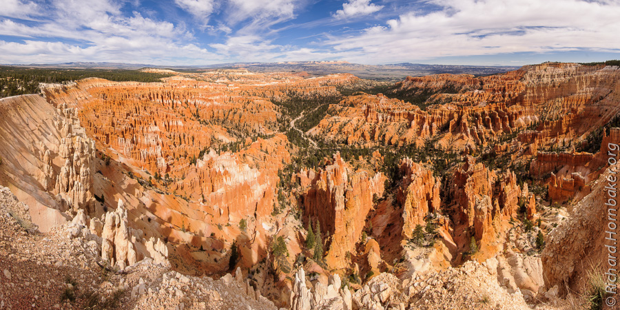
Bryce Canyon National Park

We arrived at Bryce Canyon around 2:00, stopped by the visitor’s center for some guidance and souvenirs, then went straight out to start shooting. We worked our way down all of the observation points and trails, managing to hit the last one well before sunset. But where it had been around 70 degrees in Zion, it was closer to 40 in Bryce – when the sun was behind the clouds, I really felt it!

The weather was lightly cloudy, transitioning to mostly cloudy as the day wore on; at times we’d lose our light, but within a few minutes we’d have a handful of seconds to shoot with hard light. So, it took some observation, patience, and preparedness to get the shots in. There was still enough light to shoot when the sun was behind clouds, but the light became so soft that a lot of the definition in the rocks was lost.

Here’s a view into one area of the Bryce Amphitheater and its army of “hoodoo”, or stone towers.  There were hints of the hoodoo in Red Canyon, but they’re super-concentrated here in Bryce Canyon.

DDD_2059

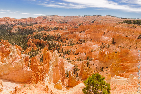
Bryce Canyon has several viewing areas, with various angles on the amphitheater and surrounding valleys.  It also has several hiking trails that take you down amongst the hoodoo, but then you can’t see the forest for the trees.

DDD_2211-Pano

I have another 7-shot panorama of the hoodoo that my different panorama stitching programs are having a devil of a time with.  My guess is the patterns in the hoodoo are too similar, and the software can’t align the shots.  That’s going to take some manual intervention in PTgui to map the alignment points.  (I’m not sure you can do that in Photoshop.)  Here was Photoshop’s attempt, aborted after several minutes of full CPU:
DDD_2115-Pano-Fail

At the end of the day we checked into Bryce Canyon Inn, a little motel with individual cabins. It was quite a pleasant surprise! For under $100 a night, the accommodations were very nice, with excellent woodwork – wood walls, exposed rafters, nicely constructed and furnished.  (You can tell I’m a woodworker.)

IMG_1281

Because we hit all the points in Bryce so quickly, and the conditions were so ideal, we decided to cut a day off our schedule and head to Canyonlands / Arches day early. The motel was very accommodating, and we were able to move our reservation up in Moab as well. Depending on how much time we need in Arches and Canyonlands, we thought we might make it to Glacier National Park in Montana as well. Little did we realize…

.

Intro | Day 1: Getting Started, Zion | Day 2: Zion
Day 3: Red Canyon, Bryce Canyon | Day 4: Capitol Reef, Canyonlands
Day 5: Dead Horse Point | Day 6: Monument ValleyDay 7: Grand Mesa
Day 8: McClure Pass, Aspen, Garden of the Gods | Day 9: Wolf Creek Pass
Day 10: Durango & Silverton Railroad, Albuquerque Balloon Festival
Day 11: Pre-dawn Balloon Launch, The End | Trip Prep | The Gear
FotoMomenti – My Comrade’s Portfolio

.

Advertisement

The Accidental Photo Adventure

Posted in Photography, Travel with tags , , , , , , , , , , , , , , , , , , , on 07 October 2013 by Richard Hornbaker

Road Trip Map

A friend and I ventured out on a 17-day photo safari. What unfolded was very different than we planned, and a lot more exciting!

My shooting partner is a consultant-for-hire, and we’d long discussed taking a photo trek after he wrapped up a multi-year project. The plan was to do a road trip and hit a bunch of US National Parks while he drove his car home cross-country. No family, just photographers, so plenty of patience for the speed of the art.

The plan was to start in Arizona, go through Utah (Zion, Red Canyon, Bryce, Capitol Reef, Canyonland, Arches, Monument Valley), up to Wyoming (Grand Tetons, Yellowstone), then Montana (Glacier), the Dakotas (Mt. Rushmore, Badlands), and through Nebraska (farmland) to Omaha where I’d fly home. 17 days, 3000 miles, and 10 national parks. Originally, the plan included Death Valley, but that was nixed due to the logistics and cost of a 4-wheel-drive vehicle to get where we’d want to shoot.

It was all going smoothly until the 5th day of our trip – October 1, 2013. That’s the first day of the US Federal fiscal calendar, and the national parks were all closed because the politicians hadn’t approved the next year’s budget. At the same time, a tropical storm that hadn’t been in the forecast started to make its way from the Pacific across the central US, leading to heavy snowfall and tornadoes along our route.  We found ourselves suddenly improvising our entire itinerary day-by-day.  Here’s the route we ended up taking:

Road Trip Map Actual

We’d planned to stay in motels along the way (rather than camp), but only the first two cities had been booked. Originally, this was because hotels to the North had excellent availability, they wanted as much as 7 days notice for cancellation, and our itinerary was still flexible. This proved more fortunate than we could have predicted.

What follows is a story that’s not so much about photography, but rather the trip from a photographer’s perspective. I’ll be adding the pages below as I process photos, for a little extra personal motivation – if you subscribe, you’ll get notified when they’re posted. I hope you enjoy it!

.

Intro | Day 1: Getting Started, Zion | Day 2: Zion
Day 3: Red Canyon, Bryce Canyon | Day 4: Capitol Reef, Canyonlands
Day 5: Dead Horse Point | Day 6: Monument ValleyDay 7: Grand Mesa
Day 8: McClure Pass, Aspen, Garden of the Gods | Day 9: Wolf Creek Pass
Day 10: Durango & Silverton Railroad, Albuquerque Balloon Festival
Day 11: Pre-dawn Balloon Launch, The End | Trip Prep | The Gear
FotoMomenti – My Comrade’s Portfolio

.